Our route will start going east from the Bridge of Lions in Saint Augustine, on the mainland side of the peninsula, by the 1A Highway. Going through the 1A / Anastasia Blvd on our bike, we’ll have proper lanes and wide sidewalks. We’ll enter through the main street of the island where we will see some of the buildings built in the nineteenth century by Henry Flagler, such as the Alligator Farm. We’ll also see many shops and restaurants on both sides of the road. We will be in the municipality of Saint Augustine Beach. Arriving at the Busam Street, we’ll go to the left and then right on Lighthouse Street. Then we’ll already be a few meters from perhaps the most spectacular and ancient landmark of this trip, the Saint Augustine Light Station or simply the lighthouse.
For several years, the lighthouse keeper's house was rented as a dwelling until an arsonist set it on fire. Between 1980 and 1981, fifteen women of the Junior Service League secured a lease with the county for 99 years and another 30 with the coast guard. Then they began restoring the buildings and managed to register the complex in the famous historical record. Like any self-respecting old building in Saint Augustine, it is also said to be the scene of apparitions and paranormal events.
For several years, the lighthouse keeper's house was rented as a dwelling until an arsonist set it on fire. Between 1980 and 1981, fifteen women of the Junior Service League secured a lease with the county for 99 years and another 30 with the coast guard. Then they began restoring the buildings and managed to register the complex in the famous historical record. Like any self-respecting old building in Saint Augustine, it is also said to be the scene of apparitions and paranormal events.
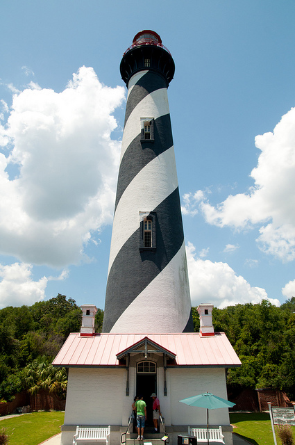
Image courtesy of Will Folsom at Flickr.com
After this stop we’ll continue south along the Red Cox Drive to merge again with the A1A, just at the entrance of the Anastasia Island State Park. This 1,600-acre reserve is an exquisite destination to appreciate the local wildlife in their natural habitat. Then we have to move for about a mile and a half as we approach the intersection with A1A Beach Blvd, a variant of the coastal road. At this point we turn west and go down a slight slope along the wide curve that ends at the beach of Saint Augustine. The sea is not visible from the street most of the time mainly for two reasons: the first is because the sand is nearly 150 meters away, plus another hundred to the water. The second is that there are from quaint cottages to large hotels and shops covering the coast on the left side. Despite this, the view is still magnificent, colorful and friendly.
Passing the Pope Rd and the motel we’ll reach the area where we’ll find the great wooden pier that goes up to 180 meters into the water and is ideal for fishing or just strolling. Around there’s a gazebo for concerts and shows, a Flea Market which functions in non working days and extensive parking spaces. From there, all the streets that we’ll cross will end up in the sand. In some of them there are wooden bridges that will bring us closer to the water, since in some sections access is dangerous due to the presence of rocks. Thus, taking advantage of one of the streets that penetrate the beach, namely the A Street about a mile from the dock, we’ll go westwards where countless vehicles also access and roam the coast. Then back to the road to continue moving south. Shortly after, the A1A will merge again with the A1 as we reach an inhabited enclave which is a Census Designated Place called Butler Beach, which will be followed by another one called Crescent Beach.
Then we’ll get to a monument that is part of the national park system, Fort Matanzas, built by Spanish troops in 1740. However, the structure is in another one of the barrier islands -Rattlesnake Island- which is accessible only by sea. The building, which is within walking distance from our shore is located on the Matanzas River, almost at its mouth.
After this brief stop we will continue on the last leg of the journey across the sea passage of Matanzas Inlet to the Islands of Hope and Pellicer Creek Aquatic Preserve on the background. Soon we will be coming to the area of Summer Haven, which refers to the qualities of Florida as a vacation site. After this, we will be entering Flagler County. The area is dedicated to the prosperous businessman who did so much for the Sunshine State. Finally, once we cross the border between the two territories, we’ll arrive at Marineland, a village of only six residents which is home to one of the first theme parks in Florida and is dedicated to dolphins since 1938. Here we’ll enter the enclosure and reach the sea, completing the first half of the course.
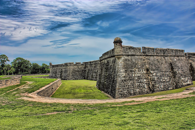
Image courtesy of Evangelio Gonzalez at Flickr.com
After having contemplated the dolphins at Marineland, we’ll get to the A1 highway, going north and going again on A1A Beach Blvd, but without getting to the lighthouse this time. Returning to the Bridge of Lions, we will have ended our journey.
Recent contents
Read Patrick Dwyer’s “A bike ride through Verna, Oneco and Samoset”
Recent contents
Read Patrick Dwyer’s “A bike ride through Verna, Oneco and Samoset”
 RSS Feed
