Image courtesy of inazakira at Flickr.com
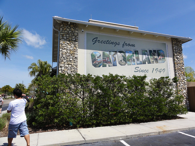
Right outside the town of South Bay, a small rural enclave located near Lake Okeechobee, heading south as we go along the Claude Pepper Memorial Highway or US Highway 27, where a sign announces the limits of the municipality, we will see to the right a green building covered in weed where it says “Live Alligators”. It’s Gatorland, one of the many Florida attractions that showcases the wonders and the ferociousness of the peninsular nature. With a multitude of snakes, alligators and felines, the place was created in 1949 and it had a souvenir store, a restaurant and a gas station. “The finest collection of Everglades animals” was the slogan used to attract travelers. Ran by Mary Lou Bowen and her husband until the 1990s, it is currently abandoned among other vestiges such as gravel quarrels converted into artificial lakes and an electrical substation of the FPL company, which is still operating today. Those were other times.
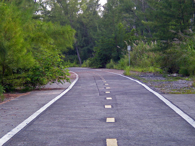
We are approximately on the 72nd mile of a road that up until about four or five decades ago was the backbone of tourism and transportation in the Sunshine State, and the landscape has definitely not changed much since then. Before the construction of the interstate highways, this road, almost 1900 miles long, goes through Florida starting in Miami’s Little Havana until another Havana, a small settlement of 1700 inhabitants located at the border with Georgia. Then, the road that currently has two lanes in each direction, well separated by an extended median and a broad shoulder which we’ll use with our bike, continues up until South Grayling by the Huron Lake in Michigan.
We are approximately on the 72nd mile of a road that up until about four or five decades ago was the backbone of tourism and transportation in the Sunshine State, and the landscape has definitely not changed much since then. Before the construction of the interstate highways, this road, almost 1900 miles long, goes through Florida starting in Miami’s Little Havana until another Havana, a small settlement of 1700 inhabitants located at the border with Georgia. Then, the road that currently has two lanes in each direction, well separated by an extended median and a broad shoulder which we’ll use with our bike, continues up until South Grayling by the Huron Lake in Michigan.
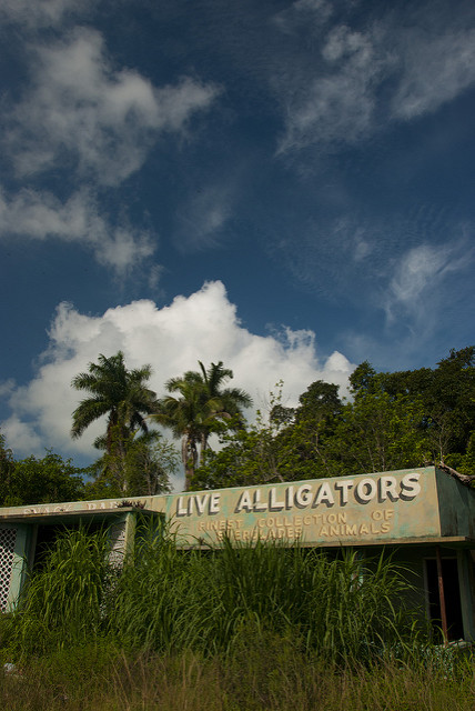
Image courtesy of DL Duncan at Flickr.com
The sight is lost in the distance among drainage pipes, irrigation, farm machinery and water pumping stations everywhere. A century ago all of these territories were inundated, they were part of the Everglades and it was used through great engineering projects in order to allow farming. The ground is made out of an extremely fertilized, dark land that, according to the direction of the wind, goes from being an idyllic postcard to an intense manure-smelling hell. Three miles after the beginning of our journey, we will Cross County Highway 827 and the broad Bolles Canal on top of which Fruit Crest once stood.
Okeelanta was also located here. After the interminable plantations, US 27 turns slightly Southeast as we go by other farms such as King Ranch, Dan Griffin Sod Co, Star Ranch and Bergeron, a mining company that extracts gravel out of an immense area of land that is no longer useful for the sugar industry. Precisely at both sides of the road the titanic works of the army’s engineers are visible, moving millions of tonnes of soil to reverse the damage that for decades was inflicted to an ecosystem which is vital for the south of the region. With cities like Miami, Fort Lauderdale or West Palm Beach and more than 5 million people total, water is a vital factor. The feat of colonizing an uninhabited territory such as the Everglades, which was achieved in the late 19th century, is a double-edged sword, since it has brought benefits but it also has made animal species disappear, threatening many others, including humans.
To our left and right we will see the rectangular shapes of the canaverals, but they will be semi inundated and surrounded by large accumulations of removed land. From now on we will see more and larger pumping stations, locks, floodgates, dams and an entire system whose purpose is to manage the elemental liquid in an efficient manner. Historically, the wetlands regulated themselves in both weather seasons, dry during winter and rainy in summer. The Sawgrass River, the Everglades would advance slowly in order to later end up at sea. After the massive construction of deep aqueducts with the intention of making water flow towards the ocean with greater speed, drying the terrains and leaving them ready for their exploitation, the river’s route was truncated and it provoked a big ecological disequilibrium.
Several public and private institutions, NGOs and government agencies have put themselves to the task of returning everything to its natural state, as far as possible. Out of all the extension of the swamps, up to 50% was used for agriculture.
So if we look to our right we will see the Everglades Agricultural Area Reservoir A, one of these reserves whose main goal is to regulate the amount of liquid that departs from Lake Okeechobee and travel South, for it not to be lost in the Atlantic or in the Gulf of Mexico. At the opposite side of the road is Reservoir B and right after that we will see the Storm Treatment Areas 3 and 4, which are operated by the south Florida Water Management District. The storm treatment areas gather the contaminants filtered from plantations which are eliminated through bacterias and new vegetation.
On mile 47 and a half of the US 27, exactly 25 miles since the beginning of our trip, there is the line that divides the counties of Palm Beach and Broward and another one of those broad canals. Deem City existed here years ago. Right next to Deem City there are several natural zones that have been completely regenerated and are bogs full of animals such as alligators, panthers, bears, deers, wild boars and lynxes. We're talking about the Wildlife Management Areas Holey Land and Rotenberger. In the former, hunting is permitted, as well as all-terrain vehicles and air boats. The latter is named after Ray Rotenberg and it is one of the sections of the northern Everglades that has been less damaged by man, still having close to 20% of its original vegetation.
We will now turn around to go through the last 25 miles of this trip, all the way to Gatorland once again.
Recent contents
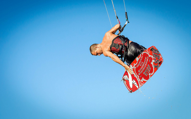
Read Patrick Dwyer’s A brief guide to kitesurfing with gusty winds
Okeelanta was also located here. After the interminable plantations, US 27 turns slightly Southeast as we go by other farms such as King Ranch, Dan Griffin Sod Co, Star Ranch and Bergeron, a mining company that extracts gravel out of an immense area of land that is no longer useful for the sugar industry. Precisely at both sides of the road the titanic works of the army’s engineers are visible, moving millions of tonnes of soil to reverse the damage that for decades was inflicted to an ecosystem which is vital for the south of the region. With cities like Miami, Fort Lauderdale or West Palm Beach and more than 5 million people total, water is a vital factor. The feat of colonizing an uninhabited territory such as the Everglades, which was achieved in the late 19th century, is a double-edged sword, since it has brought benefits but it also has made animal species disappear, threatening many others, including humans.
To our left and right we will see the rectangular shapes of the canaverals, but they will be semi inundated and surrounded by large accumulations of removed land. From now on we will see more and larger pumping stations, locks, floodgates, dams and an entire system whose purpose is to manage the elemental liquid in an efficient manner. Historically, the wetlands regulated themselves in both weather seasons, dry during winter and rainy in summer. The Sawgrass River, the Everglades would advance slowly in order to later end up at sea. After the massive construction of deep aqueducts with the intention of making water flow towards the ocean with greater speed, drying the terrains and leaving them ready for their exploitation, the river’s route was truncated and it provoked a big ecological disequilibrium.
Several public and private institutions, NGOs and government agencies have put themselves to the task of returning everything to its natural state, as far as possible. Out of all the extension of the swamps, up to 50% was used for agriculture.
So if we look to our right we will see the Everglades Agricultural Area Reservoir A, one of these reserves whose main goal is to regulate the amount of liquid that departs from Lake Okeechobee and travel South, for it not to be lost in the Atlantic or in the Gulf of Mexico. At the opposite side of the road is Reservoir B and right after that we will see the Storm Treatment Areas 3 and 4, which are operated by the south Florida Water Management District. The storm treatment areas gather the contaminants filtered from plantations which are eliminated through bacterias and new vegetation.
On mile 47 and a half of the US 27, exactly 25 miles since the beginning of our trip, there is the line that divides the counties of Palm Beach and Broward and another one of those broad canals. Deem City existed here years ago. Right next to Deem City there are several natural zones that have been completely regenerated and are bogs full of animals such as alligators, panthers, bears, deers, wild boars and lynxes. We're talking about the Wildlife Management Areas Holey Land and Rotenberger. In the former, hunting is permitted, as well as all-terrain vehicles and air boats. The latter is named after Ray Rotenberg and it is one of the sections of the northern Everglades that has been less damaged by man, still having close to 20% of its original vegetation.
We will now turn around to go through the last 25 miles of this trip, all the way to Gatorland once again.
Recent contents
Read Patrick Dwyer’s A brief guide to kitesurfing with gusty winds
 RSS Feed
