Image courtesy of Pablo FJ at Flickr.com
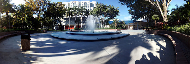
To begin, we should be on the intersection of SW 8th St / US 41 and SW 109th Ave. At the south, we’ll have the FIU (Florida International University) that was built in the grounds of the former Tamiami airport, whose control tower is still preserved.
Then, on the north side of this stretch of the 8th street we have the well-known Tamiami Canal and across the bridge over it, we’ll reach the tiny town of Sweetwater, also called Little Managua due to the large concentration of Nicaraguan citizens that live in this area.
Sweetwater was a rural community until the '60s, the airport was taken down and the university was built. Then it would be totally absorbed by the city of Miami. Currently, the city is home to about 14,000 people. Finally, although it is not a particularly large, nor particularly prosperous area, it has up to 850 commercial establishments among which there’s the magnanimous Dolphin Mall, which accommodates nearly a third of the total.
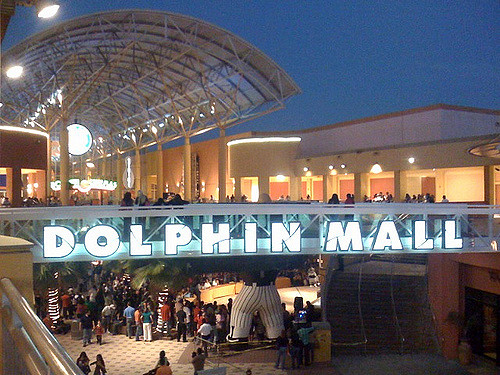
Image courtesy of Bob B. Brown at Flickr.com
Meanwhile on our route, we’ll turn right on Flagler St and then left on NW 107th Ave, crossing the Fontainebleau neighborhood. Soon, we will enter Doral, city which houses about 45,000 residents of whom 75% have Spanish as their mother tongue. It is famous for the Doral Golf Resort and Spa of whose founders comes the name of the town, by combining the first syllables of Doris and Alfred Kaskel.
On the same 107th Avenue, we find another major shopping center in the county, the Miami International Mall. Then, when you reach the NW 41st / Doral Blvd, go east. Then turn north on NW 87 Ave to cross the Executive Center Blvd, where you will see the City Hall and subsequently get to the NW 79th Ave. Here we head north and after nearly a mile, we begin to move through the NW 58th St in search again of the NW 87th Ave to keep going north. In this section, there are no sidewalks or bicycle lanes, so precautions should be maximized. Now we’ll pass in front of hundreds of industrial buildings, sales and repair workshops for vehicles and businesses of local and international shipping.
As we advance, the left side will be dominated by an impressive mountain covered externally by a pristine lawn. It is one of the municipal landfills and is located in this uninhabited area, surrounded by large swamp forests. At the NW 74th St, we will go left and see, far away, another one of these artificial terrain elevations, behind a mass of trees interrupted by this street. As the city of Doral has grown, hundreds of dirt roads have been paved over, connecting this area easily with the rest of the county. At some points, the intersections lie with their numbering, and even turn lanes lines and crosswalks, but they don’t go anywhere. They are cut off suddenly by the open forest. Again, in the NW 107th Ave, we go north as the road narrows again. On one side we have a huge residential area created not long ago, while the other will follow the eternal pine forests within which there are also huge lakes emerged from the ancient quarries of mining.
We again turn left on NW 90th St and then right onto NW 112th Ave, entering an area of office buildings and industrial buildings known as Flagler Station. Then in the NW 106th St we go in this direction and we will merge with the NW 116th Way that will lead us towards the northeast to US 27 / Okeechobee Road and the Miami River. We are now in Medley, the industrial city par excellence. Almost all of its houses are spread over the south bank of the Miami River which we shall cross to get briefly into the city of Hialeah Gardens.
Just across the Okeechobee Road / US 27, we will drive by the canal bank for a few feet until we reach the 97th Ave NW, here it is known as West 36th Avenue. By following north, the buildings begin to be more spaced and they usually are farms with crops, horses and cows. When we pass the intersection with NW 138th St, we won’t see anything other than swampy fields, pine forests, huge man-made lakes and some purely rural constructions. In the NW 154th St, the asphalt ends and we have to walk the last stretch of this route on the dark, compact land that covers this road. We have reached the area of Madden's Hammock.
Half a mile to the east, not visible from our corridor among the forest, is Interstate 75, which begins nearby. On the other side, the city of Miami Lakes. The NW 97th Ave is connected to the city by two huge bridges on the road but they are not open to traffic. The abandonment of these structures is primarily due to adjacent lands being private.
Throughout the area there are several sites and the Hammock or tree island between the bogs was built centuries ago by native Tequesta Indians who used it as a religious temple and burial site.
Once we get to the NW 170th St, which is signposted, we will move towards the bridge but we must not cross it. No barriers impede our progress except for a few stones and “No Trespassing” signs, a crime punishable by fines and jail time. At the other side is the Census Designated Place of North Palm Springs, with about 5,500 inhabitants and whose name comes precisely because of the abundance of springs. So, we will turn around and start our way back to where we started the route, with some variations from the way in which we got here. This time we’ll take the NW 97th Ave until the NW 116th Way to merge with the NW 106th Street. Now we turn left on NW 107th Ave, where we will be uninterrupted for seven and a half miles. Already in the southwestern sector of the city, we will turn west on SW 7th St until the SW 109th Ave, from where we will finally see the FIU across the Tamiami Trail.
 RSS Feed
