We begin our trip on US 17 at the point where it meets the south side of County Road 660, in the cluster of houses that represents the community of Cubitis. We are just three and a half miles north of Arcadia, the county seat of DeSoto, a gigantic rural area where farms, cattle ranches, plantations, metal windmills, barns and withered abandoned houses are by themselves telling the story of how a century ago these enclaves flourished and then died down. The road is wide, two lanes in each direction, with an unbeatable scenery. The crops in this region where the soil is almost white, sandy, are virtually limited to citrus. There are no mountains, we will never see them in the Sunshine State, but we will notice certain slopes along the entire journey. In this central area there are some more meters of elevation than on the coasts. Contrary to what happens as a rule in crowded places, people still greet each other as they walk through the old roads, even if they don’t know each other.
In three miles we’ll get to Brownville, one of the few settlements of this route where a small sign will appear on the right side of the road announcing its name. A brick building on the opposite side is perhaps the tallest one in the whole area. With only two floors and almost one hundred years since it was built, the local school has seen silently how the town has remained unchanged for decades. Currently the area is still inhabited by the descendants of the pioneers who came to this land a century and a half ago, surnames that name countless streets throughout the region.
In three miles we’ll get to Brownville, one of the few settlements of this route where a small sign will appear on the right side of the road announcing its name. A brick building on the opposite side is perhaps the tallest one in the whole area. With only two floors and almost one hundred years since it was built, the local school has seen silently how the town has remained unchanged for decades. Currently the area is still inhabited by the descendants of the pioneers who came to this land a century and a half ago, surnames that name countless streets throughout the region.
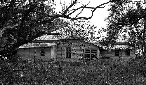
Image courtesy of Dan Tantrum at Flickr.com
On our bike, we will continue to advance three miles until the road becomes one lane in each direction. At the same time, we will be entering Hardee County which was founded in 1921 in honor of Cary A. Hardee, Florida Governor between 1921 and 1925. The Bluff Golf Course is the first thing that will appear to our right. Next up is Gardner, where we’ll see among agricultural machinery and fine horses, the Baptist church and cemetery right across, as is usual in these places. This site was originally called Calvina. The Peace River is always with us on the left, and it’ll always be less than a mile away from us. We will cross one of its tributaries, the Charlie Creek, formerly known as Charlie Apopka. In turn, the surface on top of which trains passed by until not long flows parallel to the US 17, sometimes on the left and other times on the right.
Buchanan and other inhabited spots from now on are to be found on maps and other sources because, despite being inhabited, albeit rarely, they appear as ghost towns and are not even marked on the roadside. This one specifically is located two and a half miles north of Charlie Apopka Creek. The new name was adopted in honor of John Buchanan, the manager of the Atlantic Coast Line Railroad in the area. Nearby we’ll find the great Peace River Ranch, which was owned by Ben Hill Griffin Jr., a prominent politician and Floridian philanthropist who became president of the Atlantic Land and Improvement Company (ALICO) a subsidiary precisely of the Atlantic Coast Line which even today is dedicated mainly to livestock and agriculture.
The landscape remains almost unchanged and it occasionally shows buildings of other times and at times, if it weren’t for the more recent car models, it’d seem as if we had traveled back a handful of decades. Three miles exactly on US 17, State Road 35 in the Sunshine State, we’ll get to Moffitt.
At this very moment we’ll leave for quite some time the main road going right on Moffitt Road and we’ll go further deep into the pastures and plantations. Many of the streets that we’ll cross will be made out of land and fencing wire and wooden posts. To the left, we’ll see countless greenhouses. The names on these paths or tracks are usually those of the first settlers. Then we’ll turn north, merging with the Sasser Road where the pavement ends momentarily. At the end of this section we will head east and immediately left at the Merle Langford Rd, returning again to the asphalt. Other roads that we will pass by among orange groves are the SR 66, Steve Robert Special, Lonnie Shackelford, Broadus Williams Rd, Jack Smith, Ramon Petteway or Mel Bryan. The peninsula is, after Brazil, the second largest producer of oranges.
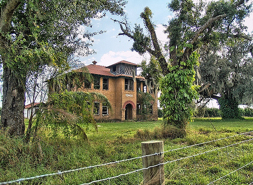
Image courtesy of Dan Tantrum at Flickr.com
Once we’ve reached the Popash Rd we’ll go right on State Road 64. One of the most important buildings here was the school built early in the twentieth century.
Returning to our route, we will continue on State Road 64 for a little less than two miles, to get to Griffin’s Corner, where we’ll merge with the Griffin Road. At this point we’ll go back on the same roads to Sasser Road and Moffit Rd, but this time we’ll move eastward instead of going to the US 17.
At the Dallas McClellan Rd we’ll turn right as the tarmac appears once again. This one is headed south even before ending up into the Sweetwater Rd, it arches westwards and then sharply continues south. Later we will go to the left, passing on top of the Charlie Apopka Creek and into Sweetwater. Now, we will go south on the Crewsville Rd but half a mile later, it detours and we’ll continue straight along the Fish Branch Rd, which again becomes a dusty gravel track. It’ll meander as we cross the Branch Fish creek, then we begin to look for US 17 by Gardner. From this point, we’ll return to Cubitis to end our tour. As for the bicycle route, it’s not a very difficult one, and at all times there’ll be a broad shoulder for us to ride. In other areas outside the US 17, traffic will be practically nonexistent.
Recent contents
Read Patrick Dwyer’s “Be prepared to self-rescue from danger while SUPing”
 RSS Feed
